Emergency Operations Centre
5:30 PM PST
The Regional District of Central Kootenay (RDCK) Emergency Operations Centre (EOC) remains in regular communication with BC Wildfire Service (BCWS) to monitor the fires within the region. There are currently 83 wildfires in the Southeast Fire Centre, with 4 wildfires of note, and 60 listed as out of control. This is a dynamic situation that can change hourly, so residents are encouraged to be prepared and follow the BCWS website and the RDCK website for the most accurate and up to date information.
For residents on Evacuation Order:
Receiving an Evacuation Order can be an emotional experience. You may be reluctant to leave your home and community. However, choosing to remain in an area that is under an Evacuation Order puts yourself, your family, and first responders in danger. Be aware that:
- Services, utilities, and businesses that you rely on daily may be unavailable or shut down;
- Evacuation routes can change or become impassible;
- Emergency medical services may not be able to reach an Evacuation Order Area because of a risk to their own safety or access is blocked;
- Friends and family will not be allowed to temporarily access the Evacuation Order to re-supply you if you stay.
Emergency Support Services (ESS) Information:
If you are on Evacuation Order, go to ess.gov.bc.ca to create a profile and register with ESS or visit one of two ESS sites in Castlegar or Kaslo. When registering for ESS online, it is beneficial to also register for the BC Services Card account, which can be done online or with an app. This account allows you to verify your identify and can streamline services and e-transfer payments provided by ESS. To learn more about the BC Services Card app, visit id.gov.bc.ca/account/. If you require assistance with online registration or renewal of ESS support, please call ESS at 1.800.387.4258.
ONLY THOSE RESIDENTS ON EVACUATION ORDER ARE ELIGIBLE FOR ESS. If you are on Evacuation Alert and voluntarily evacuate, you will not receive support at an ESS location. However, you can be proactive and create a profile online in case your Evacuation Alert escalates to an Evacuation Order.
Residents currently on ESS are reminded, whether they registered online or in person, they need to renew their ESS before it expires. Only support for food and accommodation can be renewed. Incidentals and clothing are a one time support provided per evacuee per event.
Current ESS locations for Slocan Lake Complex wildfires (includes Nemo Creek, Mulvey Creek, Ponderosa, Aylwin Creek, and Komonko Creek), Argenta Creek wildfire and Glacier Creek wildfire:
Selkirk College Castlegar Campus, 301 Frank Beinder Way
The reception centre hours are:
August 3 – 10:00 am to 2:00 pm
August 4 – CLOSED
August 5 – CLOSED
* These hours are subject to change with the dynamic wildfire situation.
Kaslo Royal Canadian Legion, 403 5th St.
The reception centre hours are:
August 3 – 10:00 am to 2:00 pm
August 4 – CLOSED
August 5 – 10:00 am to 2:00 pm
* These hours are subject to change with the dynamic wildfire situation.
Temporary Access Permit (TAP)
Temporary Access Permits (TAP) are restricted to the following:
- Critical Infrastructure or utility agencies may require access in order to service (ie. refuel, inspect) or make repairs to affected critical equipment and sites;
- Members of the agriculture sector may need to make essential repairs to fencing, evacuate or check on livestock condition and care as required;
- Community members may request access so they can retrieve important medication, tend to their domestic animals.
Temporary Access Permit Application
Temporary Access Permit Guidelines
Slocan Lake Fires Complex
We are receiving reports from the BC Wildfire Service that residents who have chosen to remain in the Slocan Lake wildfire complex Evacuation Order area are interfering with firefighting operations by entering active work zones where heavy equipment and crews are building guard.
While BCWS crews are working to install safety lines and guards to protect people and structures from wildfires, it is imperative the public do not interfere or enter these dangerous areas. Not only does it put the individual’s own safety at risk, it also slows down the BCWS crew’s and puts their safety at risk.
Residents who have chosen to disregard the Evacuation Order and remain in the area MUST stay on their own property and not travel to other properties or locations within the Evacuation Order area.
The health and safety of responders and the public is a priority for the RDCK EOC and BCWS. Please stay safe, be aware of the situation, and allow crews to do their work.
The Ministry of Transportation and Infrastructure (MOTI) has closed 35 km of Highway 6 (1 km south of Silverton to 11 km south of Slocan) to both North and Southbound traffic due to the Slocan Lake Fires Complex. Click here for Highway closure details. Area Restriction details: Slocan Lake Complex Area Restriction.
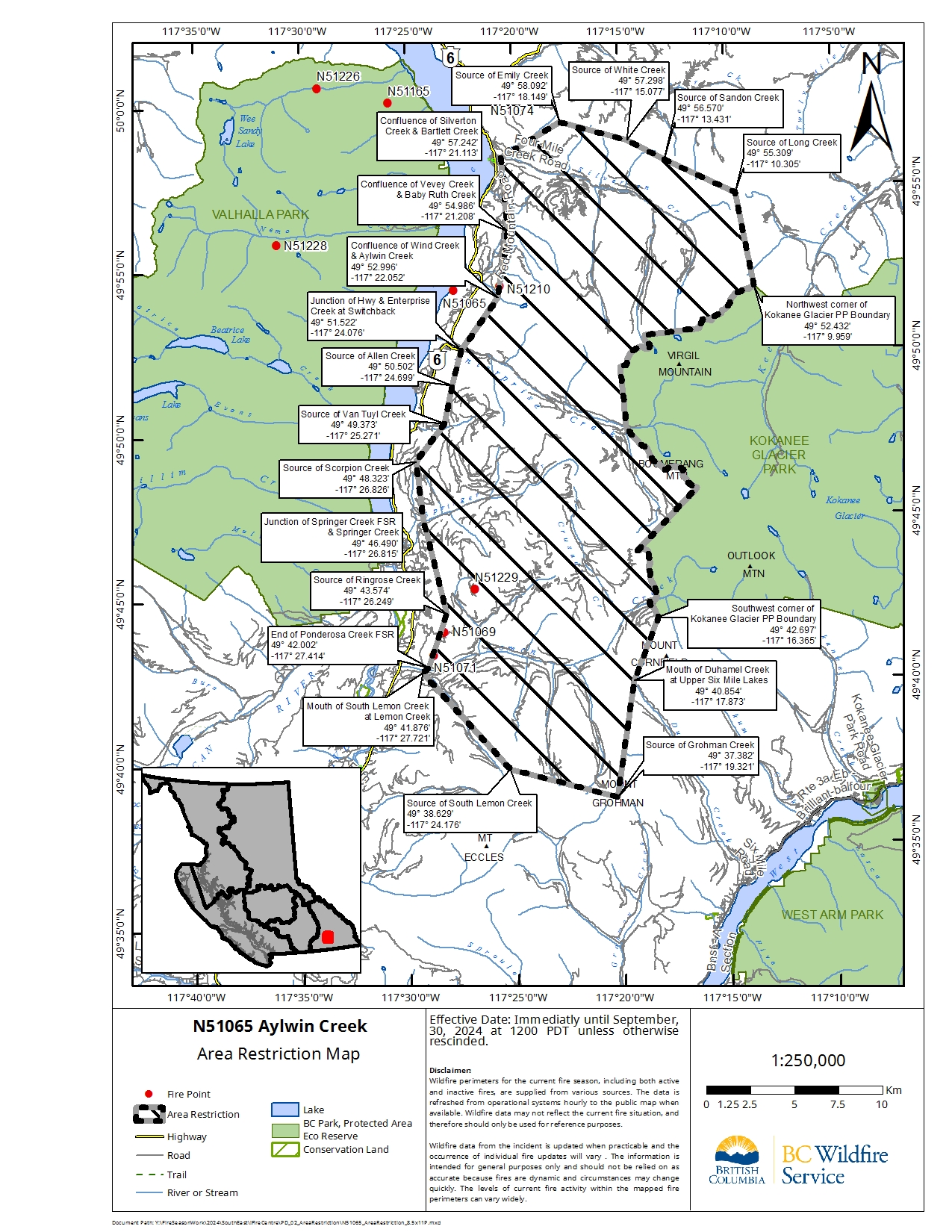
Aylwin Creek wildfire, N51065
On the recommendation of the BC Wildfire Service (BCWS) the Regional District of Central Kootenay (RDCK) Emergency Operations Centre (EOC) has issued an Evacuation Order due to this fire. Order details:
The Aylwin Creek and Komonko Creek wildfires have merged at Enterprise Creek. As of August 3, information for both fires is combined and all updates will be provided under the Komonko Creek wildfire (N51210).
Komonko Creek wildfire, N51210
Komonko Creek wildfire BCWS incident details page
Nemo Creek wildfire, N51103
On the recommendation of the BC Wildfire Service (BCWS) the Regional District of Central Kootenay (RDCK) Emergency Operations Centre (EOC) has issued an Evacuation Order due to this fire. Order details:
Mulvey Creek, N51117
On the recommendation of the BC Wildfire Service (BCWS) the Regional District of Central Kootenay (RDCK) Emergency Operations Centre (EOC) has issued an Evacuation Order due to this fire. Order details:
Ponderosa wildfire, N51069
On the recommendation of the BC Wildfire Service (BCWS) the Regional District of Central Kootenay (RDCK) Emergency Operations Centre (EOC) has issued Evacuation Alerts due to this fire. Alert details:
Wilson Creek, N51614
The Wilson Creek wildfire has been categorized as under control. As a result the Evacuation Order and Alert due to the wildfire have been rescinded, specifically for the Village of New Denver north to the community of Rosebery. Please click for:
North Kootenay Lake fires
Area Restriction details: Mt Lavina Area Restriction
Argenta Creek, N71058
On the recommendation of the BC Wildfire Service (BCWS) the Regional District of Central Kootenay (RDCK) Emergency Operations Centre (EOC) has issued an Evacuation Order due to this fire. Please click for:
Area Restriction details for Argenta Creek area
Lower Meadow Mountain N71101
Lower Meadow Mountain BCWS incident details page
Glacier Creek, N71098
On the recommendation of the BC Wildfire Service (BCWS) the Regional District of Central Kootenay (RDCK) Emergency Operations Centre (EOC) has issued an Evacuation Order due to this fire. Please click for:
On July 27 BCWS merged the Glacier Creek wildfire information with the Argenta Creek wildfire.
Howser Ridge 3, N71144
On the recommendation of the BC Wildfire Service (BCWS) the Regional District of Central Kootenay (RDCK) Emergency Operation Centre (EOC) has issued an Evacuation Alert due to this fire. Alert details:
Area restriction details for Howser Ridge 3
General Information
For more information on the wildfires refer to BCWS website, BCWS Facebook and BCWS X.
Visit www.rdck.ca/eocinfo for the complete details of all current evacuation orders and alerts. Follow the RDCK on Facebook and X. Affected residents with any questions can contact the RDCK Emergency Operations Centre (EOC) at 250-352-7701.
Click here for a print-friendly version.


