250-352-8165
plandept@rdck.bc.ca

Representing Diverse Communities in the Kootenays
The Regional District of Central Kootenay initiated an Aquifer Vulnerability Assessment in response to concerns regarding water quality and quantity in the community of Shoreacres during the initial review of the Official Community Plan for the Area I. This project was initiated in January 2019.
The purpose of the Aquifer Vulnerability Assessment was to develop aquifer vulnerability mapping to inform land use policy and decision making within the project area. The report is intended to be a ‘screening tool’ and is not intended to guide site specific land use decisions at this time.
Communities included in this assessment are:
Portions of South Slocan
The Regional District held presentations in the communities of Shoreacres and Crescent Valley on Monday, January 27th and Wednesday, January 29th, 2020. To view the presentation made to the Shoreacres and Crescent Valley communities, please use the following link: Presentation [PDF - 1 MB]
The presentation at Shoreacres was filmed and the video can be access here: https://youtu.be/-NVayaiccwo
Questions and comments heard at the meeting as well as online survey responses are captured here .
Community feedback was shared to a working group including representatives from RDCK, Interior Health Authority, Ministry of Transportation and Infrastructure and Shoreacres Neighborhood Community Association.
Intrinsic Aquifer Vulnerability Mapping is used to describe the relative degree of natural protection of groundwater resources from contamination due to the physical characteristics of the land and subsurface. This type of mapping is conducted at a regional scale and is used as a screening tool that can be used to support the regulation of land use in sensitive areas. These overview studies are not intended to replace site specific investigation or to be used for lot scale assessment.
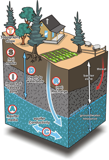
The name DRASTIC represents each of the seven input parameters:
Attributes are mapped and rated according to their relative ability to protect the groundwater resource from contamination.
D As water depth decreases, vulnerability increases, as contaminants can reach the aquifer more rapidly with less potential for natural dispersal
R As recharge to the aquifer increases, vulnerability increases, as downward movement of a contaminant is promoted
A The larger the grain size (sand versus silt or clay) in an aquifer leads to higher vulnerability due to permeability
S Course textured soils or thin soils will have higher vulnerability than fine textured soils
T As slope increases, vulnerability decreases as contaminants are more likely to run off than infiltrate
I The vadose zone is the unsaturated area below the soil and above the water table or aquifer
C As the aquifer hydraulic conductivity increases, vulnerability increases, as water and contaminants can move quickly and spread

|
HIGH VULNERABILTY Material above the water table or aquifer provides the least natural protection from surface contamination. These areas are typically unconfined sand and gravel aquifers which have low depth to water, a high water table or high permeability. |
|
MODERATE VULNERABILTY Material above the water table or aquifer provides limited natural protection from surface contamination. These areas are typically unconfined sand and gravel aquifers which may have deeper water tables or some fine grained sediments, such as silts and clays, above them |
|
LOW VULNERABILTY Material provides the highest degree of natural protection relative to other areas. This does not mean there is no vulnerability. These areas are usually well confined aquifers with un-fractured bedrock, low permeability or aquifers with deep water tables. |
Aquifer Vulnerability Reports and Mapping can be used in a number of ways to inform community decision making. The report and associated mapping will inform the following:
INTERIOR HEALTH AUTHORITY - CLEAN DRINKING WATER
ENVIRONMENTAL PROTECTION AND SUSTAINABILITY - GROUNDWATER WELLS AND AQUIFERS
The content on this page was last updated October 19 2020 at 3:39 AM