250-352-8165
plandept@rdck.bc.ca
Representing Diverse Communities in the Kootenays
Community Planning is a participatory process in which residents, property owners and other agencies and stakeholders develop a vision and objectives for their respective communities.
For updates on the Area H (North) Community Planning Conversations, visit the project page:
Planning is meant to be a collaborative process. The creation of Official Community Plans and Zoning Bylaws require information, feedback and review from the community.
Informational virtual meetings were held in 2021 for Electoral Areas D and E. Additional meetings are planned in 2022 for Area H.
In 2020, the RDCK Board passed individual resolutions brought forward by Chair Watson, Director Popoff, and Director Faust, who requested that Staff host these sessions in their respective Electoral Areas. This was in response to receiving interest from their residents in exploring land use regulations as a way to address community concerns around land use, growth and increased development. With increasing pressures, this is a good time to ask if zoning is the tool communities would like and, if so, where and what does that look like?
Planning addresses the use of land, resources, facilities and services in ways that secure the physical, economic and social efficiency, health and well-being of urban and rural communities.
Planning can be a way for the community to work with their local government to address local land use concerns including directing where new development should go, identifying where lands should not be developed, protecting rural character, water sustainability, private land logging, cannabis, short term rentals etc.
Planning is a service provided whether you have a ‘plan’ or ‘have no plan’ and does not result in increased property taxation. All Electoral Areas currently pay into the planning service as some land use bylaws such as the Floodplain Management Bylaw and Subdivision Bylaw are applicable everywhere in the RDCK.
Your assessment is completed by BC Assessment and based on the market value of your property as of July 1st of the previous year. BC Assessment has a professional appraisal staff and an extensive database that is periodically updated with information gathered through appraisal inspections. Municipal and provincial agencies inform BC Assessment of land title changes, building permit approvals and zoning adjustments. When determining the market value, BC Assessment appraisers consider your property’s unique characteristics, including:
An Official Community Plan (OCP) is a statement of the objectives and policies of the local government respecting land use in the area covered by the OCP.
OCPs include policies on:
Parts of an OCP can be specific to each individual community or can be directed to an overall framework for the wider plan area under review.
The making of an OCP is a collaborative process with extensive consultation with the public, local business owners, community associations, non profits, First Nations, school districts, and other government agencies.
The purpose of an OCP is to guide future land use decisions by local and provincial governments for the next 10 to 20 years. An OCP can be adopted on its own or with a set of regulatory bylaws to implement the OCP’s policies. The strength of an OCP is that all bylaws adopted after the OCP must be aligned with its polices. OCPs themselves only regulate land use with Development Permit Areas.
If residents desire their local government to direct land use activities to certain lands and not others or otherwise direct growth within their communities, that community would have to set up a regulatory bylaw. Zoning bylaws regulate how land, buildings and other structures may be used. Zoning bylaws may divide the whole or part of an area into zones, name each zone and establish the boundaries of those zones.
The following may be regulated within a zone:
Zoning implements the land use planning visions expressed in an Official Community Plan (OCP), as a Zoning Bylaw must be consistent with the policy framework adopted in an OCP.
| Pros | Cons |
| Can give residents a say in what land uses are located where in their community | Can limit some individual property freedoms (land use, where structures can go, height, etc.) |
|
Can prevent incompatible land uses from being next to one another (ex. A rock crushing plant next to a retreat centre) |
Can discourage certain types of development (ex. Industrial activity in residential areas) |
| Can protect/enhance property values | Can increase the cost of building new structures (ex. Screening industrial buildings) |
| Can create buffers between disruptive land uses and neighbourhoods | Can present barriers for historic mixed use neighbourhoods in older communities |
| Can preserve existing neighbourhood character (minimum lot sizes, height, setbacks, etc.) | Can limit development potential of previously existing land uses and structures if zoning standards become more restrictive (ex. Lot sizes) |
|
Can help achieve goals and objectives of OCP by adding regulatory requirements |
Can lead to a need for increased staffing to ensure proper enforcement |
If there is an Official Community Plan:
Regardless of if there is an Official Community Plan:
Some Electoral Areas have bylaws for their entire geographical area, some for partial areas, some none at all. Some Electoral Areas have an Official Community Plan and Zoning Bylaw, some only a Official Community Plan.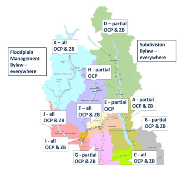
The RDCK has a public webmap that is a great tool for determining what may impact individual properties. You can take a look at whether a property falls within an OCP area, what zone it is in (if a zoning bylaw is in place), whether the property is within the ALR and much more. The ‘Community Planning Services’ Layer provides Planning related information while there are many other layers related to other RDCK Services. You can access the New Public Webmap from the RDCK’s mapping webpage: https://rdck.ca/EN/main/services/mapping-gis.html
You can find all of RDCK’s Land Use Bylaws here: https://rdck.ca/EN/main/government/bylaws/land-use-planning.html
The content on this page was last updated December 8 2023 at 5:43 AM